IMIS - Marine Research Groups | ||
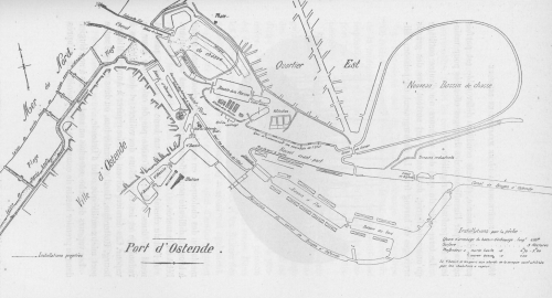
 De Zuttere (1909, fig. 11)
Description Plan van de haven van Oostende begin 20ste eeuw.
Vissersvoorzieningen:
Lengte van de aanlegkade van het getijdendok: 650 m.
Oppervlakte: 3 hectares.
Diepte bij hoog- en laagwater, respectievelijk 4,70 m tot 5,60 m en 1,00 m.
Het eerste dok en de kades dicht tegen de vismijn werden gebruikt door de stoomtreilers.
Plaats: Oostende
JPG file - 385.97 kB - 2 542 x 1 378 pixels
Extra information
added on 2009-09-081 006 viewsFrom reference De Zuttere, C. (1909). Enquête sur la pêche maritime en B...
FileName: 25176.jpg FileDateTime: 1252420115 FileSize: 385968 FileType: 2 MimeType: image/jpeg SectionsFound: ANY_TAG, IFD0, THUMBNAIL, EXIF COMPUTED.html: width="2542" height="1378" COMPUTED.Height: 1378 COMPUTED.Width: 2542 COMPUTED.IsColor: 0 COMPUTED.ByteOrderMotorola: 1 COMPUTED.Thumbnail.FileType: 2 COMPUTED.Thumbnail.MimeType: image/jpeg Orientation: 1 XResolution: 300/1 YResolution: 300/1 ResolutionUnit: 2 Software: Adobe Photoshop CS4 Windows DateTime: 2009:09:04 12:43:16 Exif_IFD_Pointer: 164 ColorSpace: 65535 ExifImageWidth: 2542 ExifImageLength: 1378
This work is licensed under a Creative Commons Attribution-NonCommercial-ShareAlike 4.0 International License
Click here to return to the thumbnails overview |